Discover a world of exploration with over 100 types of maps at your fingertips, including the renowned Geographical Survey Institute map. Whether you're scaling mountain peaks or strolling through urban landscapes, our app utilizes these maps to maximize the impact of height differences, enhancing your navigation experience.
We're proud to have received the 2018 Japan Cartographic Society Award for Best Work, a testament to our commitment to excellence in mapping technology.
- Leverage our "super terrain data," a unique technology designed to emphasize terrain features for a more immersive experience.
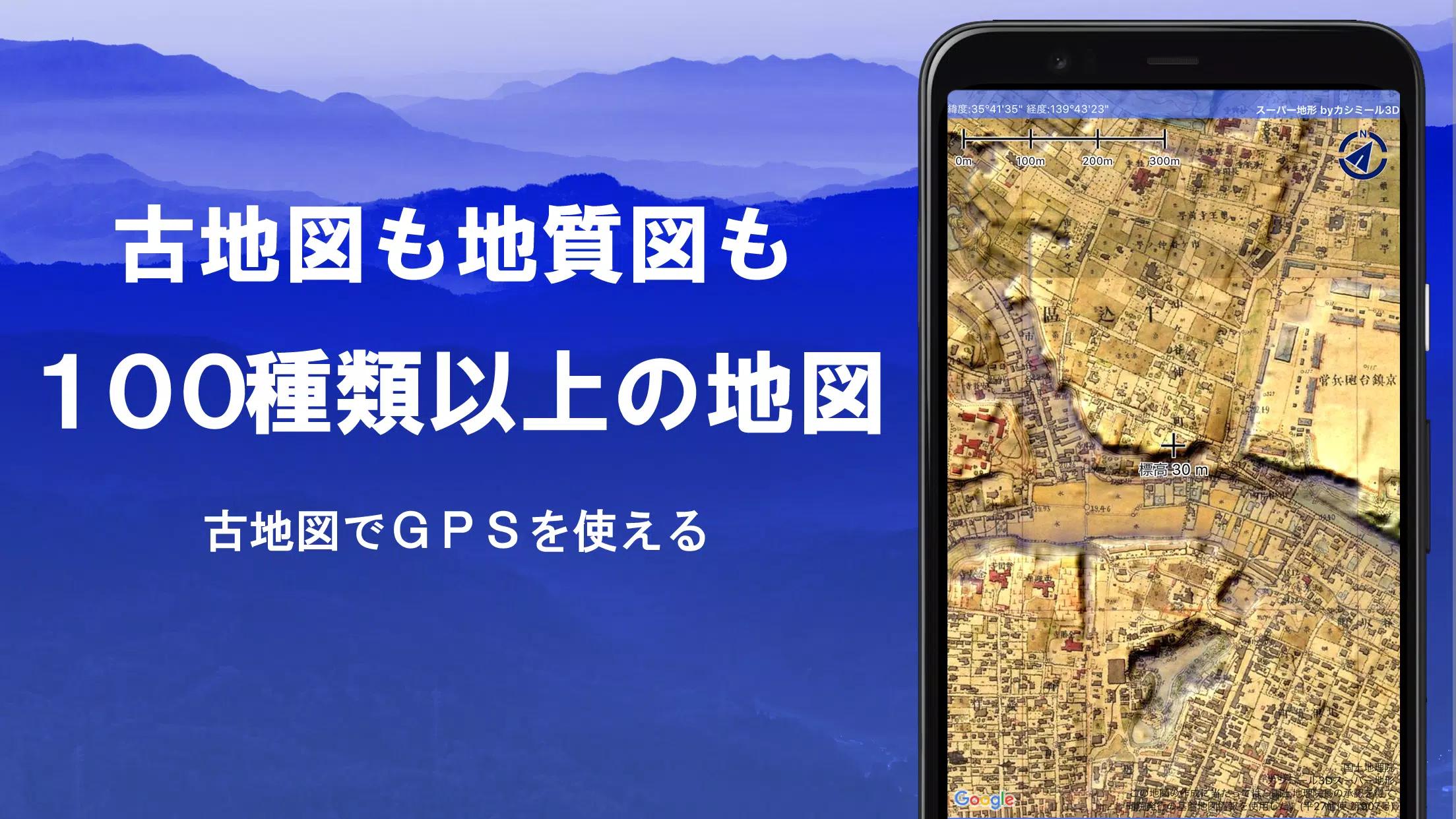
- Access an extensive collection of maps from the Geospatial Information Authority of Japan, including topographic, geological, historical, and prewar Ordnance Survey Department maps.
- Record your journeys with precision using the GPS function, complete with GPX log input/output and editing capabilities.
- Benefit from a suite of features tailored for urban walks, mountain climbing, and outdoor adventures, such as GPS navigation with audio cues, and data recording and editing.
- Utilize the visibility determination function for creating cross-sectional diagrams, aiding in observations and radio communications, with the added ability to display buildings.
- Explore with a 360° panoramic view function, which includes mountain identification, as well as sun, moon, and GPS point displays.
- Enjoy offline capabilities with bulk map downloads and a map cache function, perfect for areas with no radio signal during your outdoor excursions.
- Enhance your maps by associating photos with specific points.
- Visualize terrain with contour lines generated from elevation data.
- Display the Military Grid Reference System (MGRS) or UTM grid for precise location tracking.
- Read, display, and edit GIS data from GeoJSON files, and draw shapes directly on the map.
- Utilize the app globally, with options for map printing and PDF output.
- Enjoy a user-friendly dark theme for extended viewing comfort.
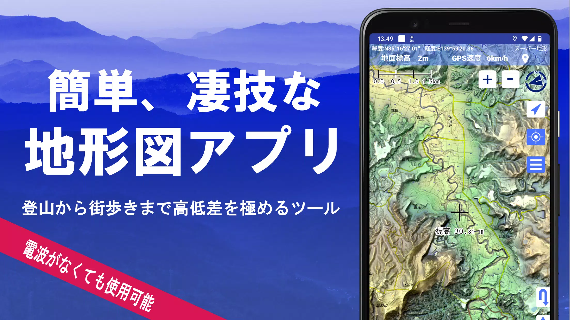
1. A Wealth of Maps at Your Disposal
Our app offers a diverse array of maps, with over 100 types available, including combinations of our proprietary super topographic data, Geospatial Information Authority of Japan maps, and hazard maps. Please note, the availability of aerial photographs may vary by age group, with "latest" and "around 1974" offering broader coverage. Enjoy a 5-day free trial of maps utilizing super terrain data upon installing the app.
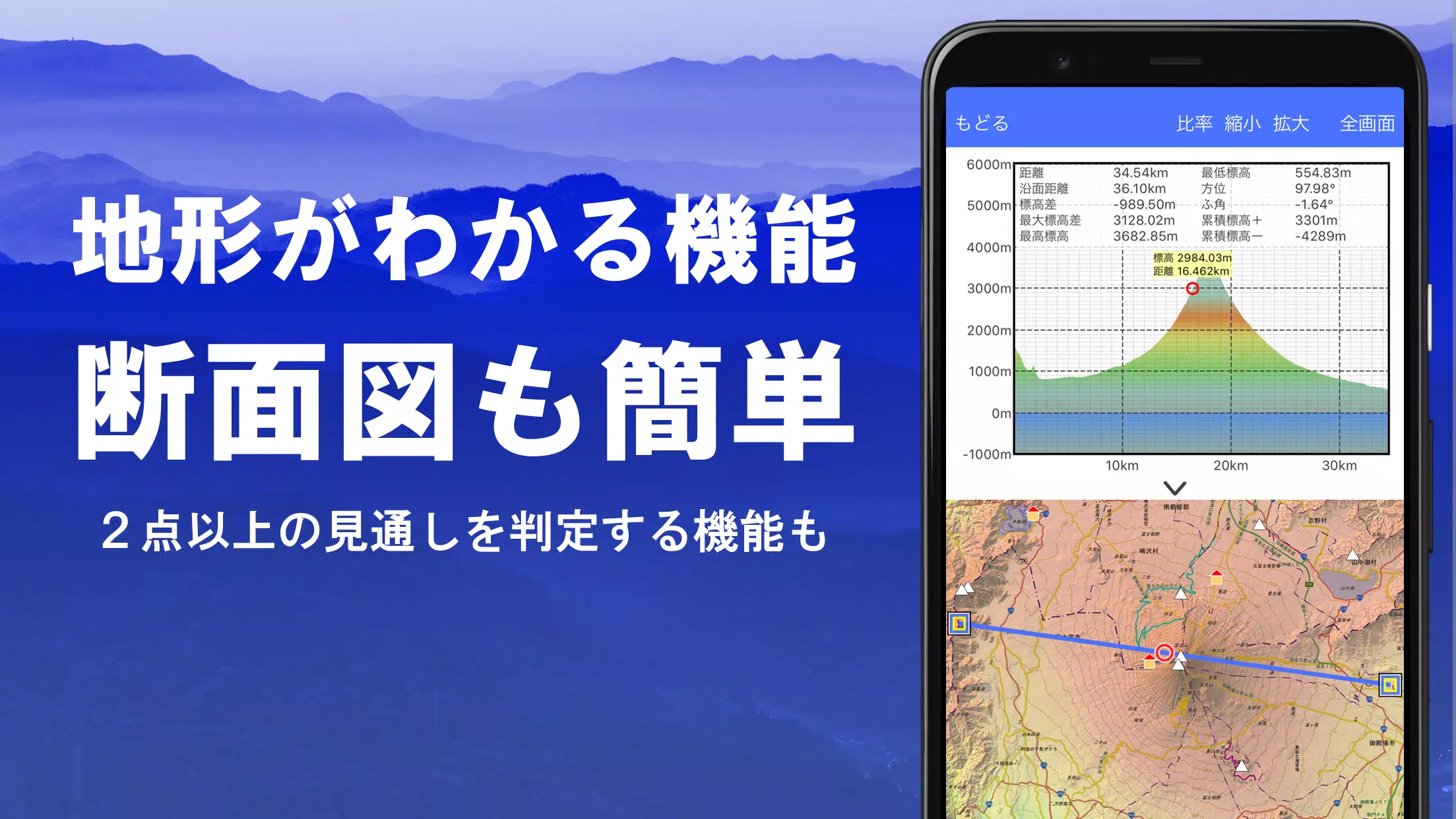
2. Cross-Section and Outlook Creation
Effortlessly generate cross-sectional diagrams through any point on the map. Our app includes the renowned visibility judgment function from Kashmir 3D, considering Earth's curvature and atmospheric variations for accurate calculations. This feature is invaluable for route planning during climbs, assessing wireless visibility, and understanding terrain. Where PLATEAU building data is available, create detailed cross-sections that include buildings.
3. Elevation Palette Function
Customize your map's appearance with the elevation palette function, allowing you to change the map background color to your preferred gradient in 1cm increments.
4. Panoramic View
Experience panoramic observation maps that display mountain names from any point on the map. The 360° panorama integrates with your smartphone's compass, making mountain identification a breeze. Additionally, view the sun and moon, including moon phases, perfect for capturing Diamond Fuji and Pearl Fuji. You can also see GPS point locations and generate panoramic views of mountains abroad.
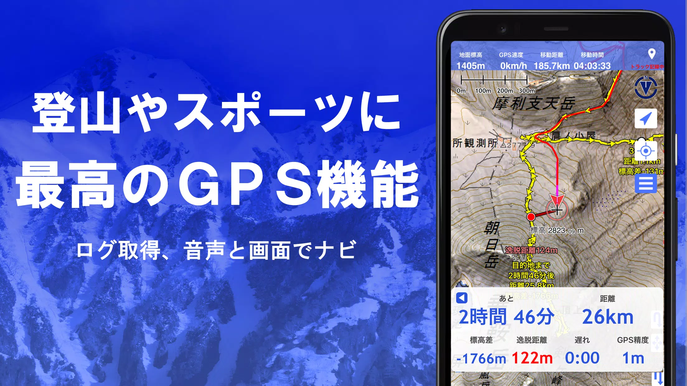
5. GPS Function
Utilize your smartphone's GPS to obtain precise location information and record your tracks. Our app supports high-precision position measurement suitable for serious mountain climbing and outdoor activities. Graphically display recorded tracks with parameters such as elevation gain, speed, time, and elapsed time. Receive voice and alarm notifications as you approach designated points with the point alarm function, and view photos linked to specific locations. Share map center positions with NaviCon.
6. GPS Track Summary Playback
Replay your tracks seamlessly, with the app automatically displaying photos taken during your journey based on their timestamps. Tap on photo icons to view them at their exact locations.
7. GPS Navigation Function
Navigate effortlessly along preset tracks with our Track Navi function, utilizing your smartphone's GPS. Receive voice or alarm alerts if you stray from your route, ensuring you stay on course during climbs. Additionally, utilize route navigation for urban exploration and point navigation to reach specific destinations.
8. GPS Data Editing Function
Manage GPS-related points, routes, and tracks with ease. Organize your data into folders, viewable in a clear tree format. Create tracks directly on the map and import or export data in GPX format from various mountain climbing sites.
9. Map Usage Outside the Service Area (Offline)
Continue your adventure even in areas without signal, thanks to our bulk download function, which allows you to download all scale maps for a specified plot. Easily monitor your downloads to ensure you're prepared for any location. The app also features a cache function for offline use.
10. Map History Function
Quickly revisit previously viewed locations with our map history function, which remembers your past explorations.
11. Custom Map Compatibility
Import and utilize custom maps crafted with Kashmir 3D's map cutter. Display and use your own maps or scanned images as navigational tools. When using the map cutter, ensure each image is roughly 256 x 256 pixels and send the resulting kmz file to Super Terrain via email or Cloud Drive.
12. GeoJSON Compatibility
Effortlessly display and edit points, linestrings, and polygons from GeoJSON files, and create new shapes to enhance your maps.
13. Print/PDF Output
Print any map area at a specified scale or generate a PDF for detailed analysis or sharing.
14. Collaboration with Other Apps
Seamlessly input and output GPS data in GPX, KML, and GDB formats, allowing for data exchange with other apps, Kashmir 3D on your PC, and trajectory data from mountain climbing sites.
15. Backup Function
Safeguard all app data (excluding cached maps) with our backup function, which can be removed from your smartphone for safekeeping. Restore your data even if you delete the app or face device malfunctions. Benefit from automatic backups via Google Drive to maintain up-to-date records. For detailed instructions, please refer to the manual.
16. About Billing Function
Some features, including maps with super terrain data, GPS track functions, and cross-sectional views, are available through in-app purchases. Post-purchase, you'll enjoy increased search results for place name searches. The annual payment is 780 yen/year, with a 5-day free trial available upon first installation. Some features and maps will become unavailable after the trial period unless you opt for a purchase. You will not be charged unless you actively make a purchase. To proceed, navigate to [Settings] - [Purchase to remove functional restrictions] within the app. Manage or cancel automatic updates through Google Play under "Regular Purchase" - "Super Terrain". Note that prices may change with future enhancements, so early purchase offers the best value.
17. Terms of Use
The copyright holder and developer are not responsible for the outcomes of using this application. Upon first use of GPS, you will be prompted to allow location information services. Be aware that continuous GPS use can drain your battery; if your device is crucial for emergency communication, carry a spare battery. For a comprehensive understanding of the navigation function, refer to the PDF guide at https://www.kashmir3d.com/online/superdemapp/superdem_navi.pdf. Note that some smartphones may interrupt or fail to record tracks due to power-saving features that close background apps; a workaround is to keep the screen on, though this is not a permanent solution.
Tags : Maps & Navigation